Before actually choosing the license for my work I never thought about it seriously. However, I now remember my friends talking about it and their work being stolen because they were never told how to protect it properly. Therefore, I decided to choose the licenses below, because even though it allows to use my work for further development, it can’t be used commercially and it needs to credit me. However, in future, if I decide to continue with my blog and produce more quality work, I will put under the most restrictive license, unless my aim will be to share my work with public for further development.
3D modelling and virtual reality has been successfully used in archaeology and has a number of advantages relating heritage and actual presentation of archaeological data in nowadays societies. Today we are bombarded with various visual information and in a way, trained through media to respond to it and to be stimulated by it. So, it is only natural we attempt to use it in various disciplines including archaeology. Even though VR and 3D reconstructions are still relatively scarce in archaeological projects, we have a number of examples of their successful integration, and even more of their use in cultural heritage. One of the best examples, is the case of Çatalhöyük and its virtual reconstruction in Second Life (Morgan 2009). I believe one of the most important factors of communicating archaeology this way is the possibility to attract wider audiences, especially the younger ones, to actually interact with archaeological data, be part of it and create your own interpretations. It is a powerful tool to make archaeology interesting and urge people to research the past. There are numerous other examples where 3D reconstructions could be used, from landscape reconstructions (Winterbottom and Long 2006) to virtual exhibitions (Bruno et al. 2010).
Fig. 1 Model of King’s Manor (Source: the Author)
For this weeks exercise we were using Sketchup 3D modelling program. We were given a map of King’s Manor in York to produce a model of it. Originally we were asked to just make a front wall and use a picture of the main entrance of Kings Manor as a texture. I was quite interested in this exercise and in 3D modelling in general, so I traced all the walls on the map to make a full model (Fig. 1). I had to use a ‘draw line’ pencil and zoom in quite a lot to be able to make it more accurate. I found this program not well suited for a very precise and accurate work when dealing with irregular shapes. Also, regarding the model in general, I realized, in order to make a full model with doors, windows and roof, a simple map like this is not enough, and more picture references are needed to add these features. This type of model, if further developed, could be used in any report regarding King’s Manor building or an example for Sketchup modelling and could reach any audience interested in building modelling.
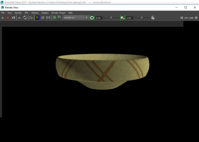
Fig. 2 3D model of a Roman vessel from Malton in progress (Source: the Author)Fig. 3 Rendered reconstruction of Roman vessel in Maya (Source: the Author)
I was always interested in possibilities of 3D modeling and after this module even more so. Therefore, as I found 3DsMax installed on the university computers, I decided to use the opportunity and practice working on it. My aim was to produce a reconstruction of one of the Roman vessels found during the Malton excavations last spring. I made a scale drawing of the sherd (Fig. 3 in my Illustration post) and took some pictures of it for texture reference to be used for a 3D reconstruction (Fig. 2). However, eventually I switched to Maya, another similar 3D modelling program, and I found it I had more options for texturing and rendering, so I stuck to it. (Fig. 3) The model is still in progress. I will try to produce more accurate texture and attempt to make a suitable background . When that is done, I could use it later in my dissertation as an example of one of the finds from Malton excavation. I also found that these programs are much better than Sketchup as you can achieve a higher quality work and because of their complexity and different abilities, you can create more diverse type of work.
Bibliography
Bruno, F., Bruno, S., De Sensi, G., Luchi, M., Mancusoc, S. and Muzzupappa, M. (2010). From 3D reconstruction to virtual reality: A complete methodology
for digital archaeological exhibition. Journal of Cultural Heritage, 11, 42–49.
Morgan, C. L. (2009). (Re)Building Çatalhöyük: Changing Virtual Reality in Archaeology. Archaeologies, 5(3), pp.468–487.
Winterbottom, S. J. and Long, D. (2006). From abstract digital models to rich virtual environments: landscape contexts in Kilmartin Glen, Scotland. Journal of Archaeological Science, 33, 1356-1367.
Maps provide important information about the space around us with ways to navigate it. There are different approaches in map making, and understanding, experiencing the landscape through it. Ingold (2007) gives interesting examples of how different people, from Orochon hunters in Russia to Australian aborigines, experience the landscape through wayfaring. For them, it is a journey through the landscape, making trails and traces that teaches them about their surroundings and eventually becomes a map. We, on the other hand, destination driven modern people, creating motorways and railways to get to the final destination as quickly as possible, create maps that are essential for this purpose: most accurate, including every feature there is, so we can find our way before closing the front door behind us.
Archaeological map making is an essential part of many archaeological projects. It is important to plan the objectives of it, to include the information most important to the project and reject unnecessary data. Dillon (1985, 36-46) gives a good description of the steps taken to produce an archaeological map with some examples. The actual mapping of the site in the field developed from using plane tables and alidades to Geographical Information Systems (GIS). This and other types of gathering data for mapmaking is given in Renfrew and Bahn (2008, 73-106).
Fig. 1 A map of Malton excavations 2017 (Source: the Author)
For this week’s map making exercise we were using DigiMap. It is a quite useful database, including historical, geological, ordinance survey and other maps. For my exercise, I have chosen to make a map of the excavation site in Malton that we excavated last year, because it might be useful for my dissertation if I decide to write about this site (Fig. 1). I used a 1980s historic map, because it was the best zoom fit for this case. It features the roman road (based on the areal photography), the trenches and the distribution of small finds. I also included the evaluation pits, which might become important for choosing future trenches.
If further developed, this type of map could be used in any article or report about this Roman site and would be aimed at the academic audience or anyone else researching about Roman sites in Yorkshire area. At the moment, it is for my personal use and to anyone who come across my blog on WordPress. However, later it might be used as an example for my dissertation, but it will have to be developed further depending on the questions I attempt to answer within my dissertation.
Bibliography
Dillon, B. D. (1985). 2nd ed. The student’s guide to archaeological illustrating. Los Angeles: Institute of Archaeology, University of California.
Ingold, T. (2007). Lines: A Brief History. Routledge.
Renfrew, C. and Bahn, P. (2008). 5th ed. Archaeology: Theories, Methods and Practice. London: Thames & Hudson.
We can see archaeology on film from early 1900s and a summary of the history of archaeological film-making can be found in Morgan (2014). We have strong stereotypes of archaeology and archaeologists in popular culture and movies as an adventurous journey into the mysterious and exotic places, which persists on a wider screen. Which is perfectly understandable, having in mind the objectives of the mass media, the audience they are aimed at, and the purpose of these movies. However, such TV shows as the Time Team gave us more realistic representation of archaeology, even though it still had been subjected to some critiques by the academics (Mower, 2000, Cleere, 2000). Nevertheless, it presents archaeology as best as possible to the popular audience, considering the circumstances, i.e. the way TV programs are created and their every single aspect is controlled by directors and the system of the media. It shows short version of the process of archaeological evaluation and most importantly, makes it interesting and appealing to the wider audience, which it is aimed at. Morgan (2014) also gives a list of genres of archaeological films. How the information of the film is focused on the subjects and communication depending on the different audience. It is very important to understand what kind of audience you want to reach when creating your archaeological or any other kind of film, how do you want it to affect them and what is the purpose of the film.
As part of Communicating archaeology module we were asked to make a short video featuring an interview of us, students answering various questions about archaeology and our experience in this course. The video above shows me answering the questions about my interests in archaeology, experience during the excavations at Malton and my ideas for the next year dissertation topic, while you can hear the questions asked by Jessica in the background. Even though we originally started to film it outside, in the courtyard, we ended up doing it in archaeology lab, where nobody disturbed us and it was a relaxed environment. We positioned the camera so that the interviewee was the focus of the film looking at the interviewer sitting next to the camera. The video shooting was quite problematic though as the camera did not record more than 40 seconds, so we had to record every question separately and later edit it into one video. As this was just a simple exercise of practising in making video about some experiences of archaeology students, it has been aimed to be used as a learning experience in video making, to post on our blogs. However, this type of video, if questions be slightly changed, more concentrated about the course and what is exiting about studying archaeology in York, it could be used on university website or anywhere in the social media to promote archaeology course in York. Therefore, this particular video we made is for personal use and might include the audience of our classmates, however, with some changes it could be aimed at the wider audience of archaeology and other students, or anyone, who might consider to study archaeology.
Bibliography
Cleere, H. (2000). Behind the Scenes at Time Team. Public Archaeology, 1(1), 90–92.
Morgan, C. (2014). Archaeology and the Moving Image. Public Archaeology, 13(4), 323–344.
Mower, J. P. (2000). Trench Warfare? Archaeologists Battle it Out. Papers from the Institute of Archaeology (11), 1–6.
Fig. 1 King’s Manor wall (Source: the Author)Fig. 2 One of the entrances to King’s Manor (Source: the Author)
Photography in archaeology is an important part of recording archaeological data. It is important to understand how to take photographs effectively of various archaeological material from artifacts to excavation sites. Archaeological photography has a long history of development with different ideas of how we should represent archaeology (Bohrer 2011, 27-68).
There are different types of archaeological photographs depending on the object of the photograph, which includes site photography, artefact or research and heritage and interpretation photography, all of which have their own rules of how photographs are taken. The photos, that are aimed to record specific archaeological features or artifacts always include scale, can also include north arrow and a plate with site information. The area should also be clean, the photo taken at the right angle, have an even light. When taken a photo of the artifacts, the background colour is also important.
For this exercise, I have chosen to take these archaeological photographs (above) as an example. The one on the left shows a part of the wall of the King’s Manor in York (Fig. 1). The King’s Manor had several phases of building and reconstruction (RCHM, 1975). This particular section shows evidence of rebuilding as you can still see the wooden beam, and the arrangement of stones indicates the filling of a possible doorway of some sort. The photo on the right is of the same building, one of the entrances from the smaller courtyard (Fig. 2). It shows a beautiful vintage style door, although you can see from the differences in stone, it was a later addition to the building. Both pictures show a typical archaeological building photography, which includes scale, is relatively clean and tidy, is clear, in focus and at the straight angle, so it doesn’t distort the object.
These pictures could be used in any archaeological journal article, book or report about King’s Manor and aimed to the audience dealing with buildings archaeology, specifically this particular building, although could reach anyone interested in the history of King’s Manor.
Fig. 3 (Source: the Author)
Fig. 4 (Source: the Author)
As an example of a non-archaeological photograph I’ve chosen to take a few pictures of wildlife (Fig. 1, Fig. 2). They would have nothing to do with archaeology even if there was a historical building in the background. There are no rules of how to take the picture, what must be included or not. The focus of the pictures is simply the animals in their natural environment. The reason I have chosen them is because I love nature and it is a clear example of non-archaeological photograph. The audience they are aimed at is everyone who is interested in the wildlife. These pictures could be used in any journal or website about these animals, although photos of more professional style, for specific topics would be possibly preferred.
Bibliography:
An Inventory of the Historical Monuments in City of York, Volume 4, Outside the City Walls East of the Ouse (London, 1975), British History Online http://www.british-history.ac.uk/rchme/york/vol4 [accessed 7 November 2017].
Bohrer, F. N. (2011). Photography and Archaeology. London: Reaktion Books.
I find illustration as an important medium to communicate archaeological data, whether it is an artifact or a reconstruction of a house, settlement or the whole landscape. Illustration is particularly important for recording artifacts as it can reveal more clearly little details of decoration, texture of the surface or little visible patterns where a photograph could not (Fig. 1). It could also be more cost effective, compared to some other recording methods. However, it is more than likely that in the future, with further developments in technology and eventually lower prices and better accessibility, we will find even better ways to record artifacts, particularly having in mind 3D scans and modelling, which can show every single detail of an object with a 100% clarity, and especially important for making reconstructions of fragile artifacts (English Heritage 2011, 27).
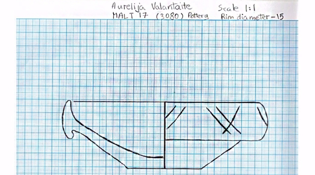
Fig. 2 Scale drawing of Roman pottery (Source: the Author)
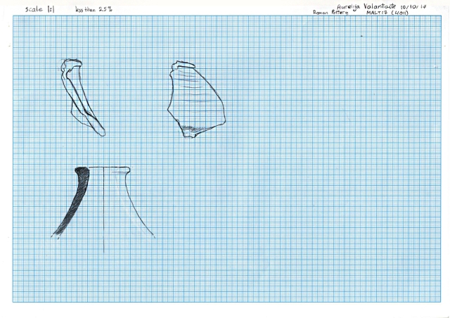
I have chosen to do an illustration of one of the Roman pottery pieces from Malton excavations we did in spring (Fig. 2). I have chosen this particular piece because it had an interesting enough shape with some curvature and little indication of the rim, also some evidence of colour change at the bottom of it from reddish to burnt brown, which I tried to indicate by shading in the front drawing of the piece. These are scale drawings in profile and front of the artifact. For a profile drawing I have chosen a dropped-pencil technique (Adkins and Atkins 1989, 159) as it is quite quick and simple, especially as the form of a sherd was not too complicated to draw, and for the front I have just traced around the object. I also included a standard profile/section drawing to show the thickness of the sherd as it gets slightly thinner from the top towards the bottom. Measuring pot radius using radius curve guides couldn’t provide an accurate estimate as very little of the actual rim survived. It is also required to do more referencing within similar Roman pottery samples to be able to make a reconstruction of the actual full shape of the pot. However, it is possible to classify it as likely a jar type vessel, based on the surviving shape of a sherd (Collett 2008, 6)
Fig. 3 A scale drawing of Roman pottery piece (Source: Author)
I also decided to do another scale drawing of a different piece of pottery (Fig. 3). I used gauges and calipers to draw the shape as accurate as possible. I have chosen this piece, because it had a full base and part of a rim so I could later in the module produce a 3D reconstruction of the whole pot.
These drawings eventually could be used in any book, journal article or report about Roman pottery as another reference sample. It would be particularly useful for the audience interested in Roman Britain pottery especially in Yorkshire area, or Malton, and for anyone doing a research on this kind of pottery as a reference. As it was found at the occupation layers just outside the Roman fort in Malton, with a broader understanding of its context, it can provide some information about type of occupation, wealth, possible trade routes within Yorkshire area and even the whole Roman Britain, so it can reach any audience interested or specialising in this type of field of expertise.
Bibliography:
Adkins, L. and Adkins, R. (1989). Archaeological illustration, Cambridge. New York: Cambridge University Press.
Collett, L. (2008). Anintroductiontodrawingarchaeologicalpottery. The Association of Archaeological Illustrators and Surveyors.
English Heritage, Barber, D., Mills, J. and Jones, D. M. (2011). 3D laser scanning for heritage: Advice and guidance to users on laser scanning in archaeology and architecture. Swindon: English Heritage.
Griffiths, N., Jenner, A. and Wilson, C. (1991) Drawing Archaeological Finds: a Handbook. London: Archetype Publications.
In summer, just before this course started, I had a chance to get involved in processing the finds from excavations in Malton last spring, next to the Roman fort. It was ideal for me as even though I was working full time, I was able to fit this activity quite nicely around my work.
It was an interesting experience and quite relaxing, most importantly, I was doing archaeology. It included washing, sorting and organising finds. And even sometimes this kind of work might look quite monotonous or even boring, it really isn’t. For example, one day I was washing bulk finds of animal bone and unexpectedly one little peace revealed some interesting decoration (photo bellow). Just little things like that makes the whole activity really exciting. So, I say to everyone who might have an interest in archaeology and consider to get involved in it hands on, it is worth it and rewarding.
The first photograph above shows the environment of the basic processing of the finds, just to show the people who might be interested to get involved in it, what to expect and the feel of it. The second photograph, shows a little piece of a decorated bone, to show that you can never know what you might notice while washing a pile of animal bones. This picture could be used in any magazine or book dealing with decorated bone, maybe more specifically from Roman period in Britain. As part of the post, the picture can reach any audience who have an interest in archaeology and maybe looking for some interesting artefacts, and as a picture itself it is more specifically aimed to people who are dealing with Roman period bone artefacts, especially Roman Britain.
Hello everyone! My name is Aurelija and I’m an undergraduate archaeology student at the University of York. This is my first blog created as part of a course to learn how to effectively communicate archaeological data to the public. This is going to be an exciting experience, and I intend to make this blog as interesting and creative as possible. Archaeology is my passion and who knows… eventually it might grow to include a diversity of subjects even beyond archaeology itself.